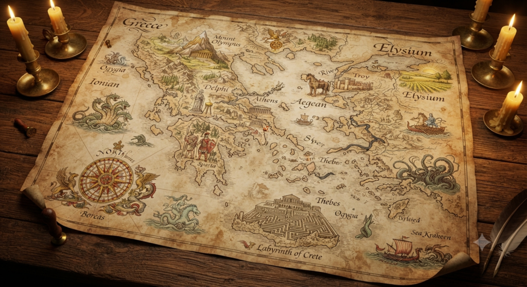
Maps of mythical Greece were never fixed in the modern sense. The Greeks imagined their world through epic poetry, sacred geography, travel writing, local cult traditions, and the testimony of poets and priests. What survived was not a single authoritative atlas, but a layered picture in which mountains could be divine thrones, rivers were gods, distant islands held the blessed dead, and the margins of the earth were crowded with monsters, winds, and impossible peoples. Mythic Greece was therefore mapped as both a landscape and a story, where places acquired meaning through memory, ritual, and divine presence.
Early Greek maps and the edge of the world
The earliest Greek attempts to picture the world are associated with thinkers such as Anaximander and Hecataeus, whose works are now mostly lost but were remembered by later writers as circular maps. In broad terms, the inhabited world, the oikoumene, was imagined as a disk surrounded by Oceanus, the great encircling river. This was not a map of political boundaries so much as a cosmological diagram, placing Greece in relation to the wider earth and to the unknown edge beyond it. Mythic geography began where ordinary travel ended.
At that edge, poets and later prose writers placed marvels, monsters, and divine presences. Hesiod and Homer already speak of distant peoples and remote lands that are nearly beyond human reach, while later tradition filled the borderlands with Hyperboreans, Ethiopians, Gorgons, and other extraordinary inhabitants. The outer rim of the map was often less a blank space than a sacred or dangerous zone, where the familiar order of the Greek world gave way to the strange.
Homeric geography in the age of myth
In Homer, geography is recognizably Greek but not strictly cartographic. The Iliad and Odyssey describe a world of named islands, bays, straits, headlands, and cities, yet the sequence of movement often follows poetic logic rather than precise navigation. Places like Ithaca, Troy, Pylos, Sparta, and Crete are anchored in memory and identity, but they are also part of a mythic network shaped by heroism and divine intervention. A Homeric map would not look like a modern coast survey; it would look like a remembered route through meaningful places.
The Odyssey especially reveals a world whose geography grows more uncertain as Odysseus moves farther from home. Some locations, such as the land of the Cyclopes or the home of Circe, are presented as part of the same Mediterranean horizon, while others feel deliberately remote and liminal. Homer blends familiar seascapes with fantasy, so that the map of Greece expands outward into an imaginative geography of tests, detours, and divine encounters. The result is a landscape where distance is measured as much by risk and wonder as by miles.
Olympus, Delphi, and sacred mountain sites
Mount Olympus stands at the center of divine topography in Greek myth, but it is also a real mountain in northern Greece, which gave the myth a powerful geographical anchor. In epic and later tradition, Olympus becomes the dwelling of the Olympian gods, a radiant height above ordinary human space. It is not merely a peak on a map; it is a boundary between mortal land and immortal order. This blending of real terrain and sacred imagination is one of the defining features of mythical Greek geography.
Delphi likewise appears both as a physical sanctuary and as a cosmically charged center. Associated with Apollo and the oracle, it was often understood as a navel of the world, the omphalos, marking a point where divine knowledge entered human affairs. Sacred mountains and sanctuary sites could function as orientation markers in mythic space, not because they were the highest or most remote, but because they connected communities to the gods. A map of mythical Greece would therefore include shrines as points of power, not simply as settlements.
Rivers, seas, and the routes of the gods
Greek mythology treated rivers and seas as animate powers, often divine in their own right. River gods such as Achelous, Alpheius, and Scamander appear in myth and epic as beings with agency, while great seas like the Aegean and the wine-dark sea of Homer are both routes and obstacles. Water on a mythic map does not merely separate places; it creates them, names them, and carries divine significance. Crossings, springs, and estuaries often mark transitions between human zones and sacred or perilous ones.
The gods themselves moved along these watery routes. Poseidon rules the sea, but other gods and divine messengers traverse it as well, and myths frequently link temples, islands, and coastal sanctuaries through maritime pathways. Ancient Greek thought rarely separated travel from ritual in a modern way; a voyage could carry omen, warning, and transformation. On mythic maps, therefore, the sea is not empty space. It is a living corridor of power, memory, shipwreck, and revelation.
The underworld beyond the known landscape
The Underworld in Greek tradition was usually imagined as a place beyond ordinary geography, yet it was frequently tied to known entrances in the landscape. Caverns, river mouths, and remote promontories could serve as gateways to Hades, as in later literary and local traditions. Homer describes the realm of the dead at the far edge of the world, beyond Oceanus, while later authors sometimes placed access points in Italy, southern Greece, or other specific localities. The exact location varied, but the principle remained the same: the dead lay outside the mapped world of the living.
This spatial remoteness gave the Underworld a distinctive place on mythical maps. It was not simply underground in a literal sense, nor was it always treated as a single fixed site. Instead, it was a destination reached through descent, crossing, or divine guidance. Rivers such as Styx, Acheron, and Cocytus helped define its landscape, and the route into that realm often mirrored a journey from light into darkness. Greek myth made death legible by giving it a geography of thresholds.
Isles of the blessed in Greek tradition
Greek tradition also imagined blessed islands at the farthest edges of the sea. Hesiod speaks of the Isles of the Blessed, where heroes favored by the gods live in ease at the ends of the earth. Later writers develop the idea in different ways, sometimes linking it to the Elysian plain, sometimes to remote islands beyond ordinary navigation. These places are not part of everyday Greece, yet they belong to Greek mythic geography as reward zones, destinations outside suffering and labor.
Such islands are important because they show that the edge of the map was not only a place of terror. Beyond the known world lay not just monsters and death, but also renewal, rest, and divine favor. In some traditions, the blessed dead enjoy a climate of perpetual spring, a kind of perfected landscape detached from seasonal struggle. On a mythical map of Greece, these islands would sit beyond the horizon, where mortal routes fade into divine provision.
Monsters, borders, and unmapped frontiers
Monsters in Greek myth often inhabit borders, sea lanes, caves, and distant regions that resist stable mapping. The Cyclopes, Sirens, Scylla, Charybdis, and the various monsters encountered by heroes all belong to spaces where normal order weakens. Their locations are sometimes specific, sometimes vague, and sometimes deliberately shifting from one author to another. This uncertainty is part of their function: they mark the limits of the known and the dangers of crossing them.
Because of this, mythical Greece is full of frontier zones rather than sharp lines. A map would show headlands, straits, islands, and mountain passes as places where the world becomes unstable. Heroes moving through these regions enter a geography of negotiation between human skill and supernatural force. The monsters do not merely decorate the map; they define its outer contours and remind the viewer that knowledge ends where divine or chaotic power begins.
Heroic journeys on mythic Mediterranean maps
Heroic travel gave Greek myth much of its spatial shape. The journeys of Odysseus, Jason, Heracles, and other figures connect Greece to the wider Mediterranean, turning the sea into a field of encounters and trials. Jason’s voyage to Colchis, for example, extends Greek heroic geography toward the eastern edge of the known world, while Heracles’ labors range from local Greek sites to far western and northern realms. These are not just adventures; they are the routes by which the Greek world imagines itself in relation to others.
Such journeys would have made a mythical map look mobile and layered. Instead of static regions alone, it would contain paths, returns, detours, and sacred stops. Local traditions often attached a hero to a particular cave, spring, tomb, or harbor, while larger epic cycles linked those places into transregional networks. The result was a Mediterranean imagined through movement, in which mythic fame could transform ordinary points on the coast into landmarks of the heroic age.
Cartography, temple lore, and local sanctuaries
Greek maps were shaped not only by poets but also by sanctuaries and local memory. Temples preserved stories about founding heroes, divine visitations, and sacred boundaries, while votive offerings and ritual calendars reinforced a place’s mythic identity. Pausanias, in particular, shows how local cult and landscape could be inseparable, with shrines, tombs, springs, and altars preserving traditions that did not always agree from one region to another. A map built from such sources would look less uniform than modern geography and more like a patchwork of sacred claims.
This local variety mattered. Different poleis and sanctuaries preserved different versions of the same myth, and those versions often altered geography as well as narrative. One place might claim a cave as the birthplace of Zeus, another as the cave of a hero, and another as the site of a divine epiphany. Mythical Greece was therefore not mapped by centralized authority but by accumulated reverence, where each sanctuary could redraw the sacred landscape in its own way.
How classical authors imagined sacred space
Classical authors treated sacred space as something distinct from ordinary space, even when the two overlapped. Herodotus, Homer, Hesiod, Pindar, Apollodorus, and Pausanias each preserve different ways of seeing the Greek world, but all recognize that some places matter because the gods have entered them, marked them, or spoken through them. Sacred groves, mountain tops, caves, springs, and crossroads all become legible on the mythic map because they are charged with divine presence. Geography and cult reinforce one another.
At the same time, these authors rarely offer a single, unified sacred map. Their Greece is plural, layered, and often contradictory, shaped by local memory as much as by panhellenic myth. A sacred site may be ancient in one account and newly founded in another; an underworld entrance may lie in one region for a poet and elsewhere for a traveler. That instability is part of what makes mythical Greece compelling. Its maps do not simply locate places. They preserve the ways Greeks imagined the land as touched by gods, heroes, and the unseen powers beyond the horizon.
A map of mythical Greece would have looked unlike any modern atlas. It would place Olympus above the human world, Delphi at a sacred center, rivers and seas as living powers, and the edges of the earth alive with danger or blessing. It would not separate legend from landscape, because for the Greeks the two were often intertwined. The result is a geography where place is never merely physical, but always also remembered, narrated, and sanctified.
Orin Vale has spent the better part of two decades tracing the threads that connect the world’s oldest stories — from the halls of Asgard to the banks of the Nile, from Olympus to the jungles of the Maya. What began as a childhood fascination with flood myths and trickster gods grew into years of independent study across comparative mythology and ancient religion, always chasing the same question: what did these stories mean to the people who first told them? Orin writes for readers who want more than trivia — the ones looking for the beliefs, fears, and truths that myths were built to carry.